Arkansas River Report – April 2024
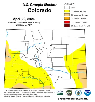
While snowpack in Colorado's northern river basins remains near normal, the southern basins have dropped well below normal, with the Rio Grande Basin at 61 percent. Likewise, the April 2 U.S. Drought Monitor report shows no drought conditions primarily in northern Colorado with "abnormally dry and "moderate drought" conditions in the southwestern part of the state and in the Lower Arkansas Valley.

©
The National Weather Service three-month outlook is leaning more strongly toward above-average temperatures for Colorado and the Arkansas River Basin than at the end of March and leans toward below average precipitation for the southwestern third of the state, including a portion of the Arkansas Basin.

©
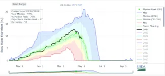
The steep drop in snowpack on the Brumley SNOTEL chart shows spring runoff has begun and snowpack is melting rapidly.
Snowpack
The latest data available from the Natural Resources Conservation Service shows Arkansas River Basin snowpack has dropped to 84 percent of median (reported as snow-water equivalent). Snowpack Telemetry (SNOTEL) stations around the Arkansas Basin report widely varied conditions with snowpack at Glen Cove (near Pikes Peak) at 211 percent, but west of Trinidad, the Whiskey Creek station reports 0 percent. Additional SNOTEL readings around the basin are:
- 117 percent at Buckskin Joe in the Mosquito Range.
- 115 percent at Porphyry Creek near Monarch Pass.
- 99 percent at Fremont Pass north of Leadville.
- 97 percent at Brumley near Independence Pass.
- 80 percent at Rough and Tumble near Buffalo Peaks.
- 68 percent at Hayden Pass in the northern Sangre de Cristos.
- 68 percent at St. Elmo in western Chaffee County.
Reservoir Storage
The Bureau of Reclamation website indicates Pueblo Reservoir is 72.6 percent full with 234,367 acre-feet of water in storage, 253,644 acre-feet a month ago. Pueblo Reservoir operations include an April 15 deadline for making flood-control space available. Any water in excess of that level must be released or "spilled," based on established priorities for different types/sources of water being stored. This year, the drop in Pueblo Reservoir water levels since March is primarily the result of different water owners moving their water out of Pueblo to ensure that they do not lose that water the to the flood-control requirement.
Turquoise Lake, also operated by the Bureau of Reclamation, is currently 57.7 percent full with 74,636.2 acre-feet of water in storage. Twin Lakes, 71.6 percent full, currently holds 100,913 acre-feet of water. The U.S. Army Corps of Engineers reports water storage in John Martin Reservoir at 55,686 acre-feet, down from 61,396 acre-feet a month ago.
River Flows
The Voluntary Flow Management Program sets a target river flow of 250-450 cfs through May 15 at the Wellsville gauge, which peaked at 850 cfs April 27 and currently reports 603 cfs. The flow targets are set to optimize conditions for fry and juvenile trout to grow strong enough to survive peak river flows during spring runoff. This year's early runoff makes spells challenging conditions for young trout.
The Leadville gauge currently reports 76.1 cfs, and daily fluctuations show influences of the freeze-thaw cycle. The gauge below Granite reads 550 cfs. River flow at Cañon City is currently 632 cfs, and below Pueblo Reservoir, 458 cfs. The gauges near Avondale and Rocky Ford currently read 910 and 578 cfs, respectively. River flow below John Martin Reservoir are 617 cfs, and the flow near Lamar is 66.6 cfs.
Calling Water Rights
The Arkansas Basin currently has 10 calling water rights and six authorized diversions. The most senior calling right is the Hoehne Ditch with an 1864 priority date on the Purgatoire River. The 1867 Lucero Ditch right on the Apishipa River is next in priority, followed by the 1868 Upper Huerfano No. 1 right on the Huerfano River. Other calling rights are:
- 1873, Whitman and Mott Ditch, Apache Creek.
- 1884, Lake Miriam Ditch, Cucharas River.
- 1886, Hogue Ditch No. 2, South Arkansas River.
- 1885, Buffalo Canal, Arkansas River mainstem.
- 1885, Sikes, Cypert and Chatham, Hardscrabble Creek.
- 1887, Amity Canal, Arkansas River mainstem.
- 1949, Arkansas River Compact, Arkansas River mainstem.
The authorized diversions are:
- 1889, Bruce Irrigating and Domestic Ditch, Cucharas River.
- 1889, X-Y Irrigating Ditch, Arkansas River mainstem.
- 1904, Dell Ditch No. 1. Currant Creek.
- 1911, Plum Creek Ditch, Plum Creek.
- 1912, New Salida Ditch, Arkansas River mainstem.
- 1927, Sunnyside Park Ditch, Arkansas River mainstem.


