
Tornadoes and large hail strike eastern Colorado Sunday; severe storms possible again Monday

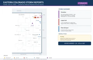
Eastern Colorado's stormy stretch turned more active Sunday, when two brief tornadoes touched down on the northeast plains and the strongest storms dropped baseball-size hail and produced damaging winds. According to preliminary National Weather Service reports, tornadoes were reported in Phillips and Washington counties, a spotter measured hail up to 2.75 inches across — baseball size — near St. Petersburg in Logan County, and a 67 mph wind gust was clocked near Wray. The unsettled pattern is not finished: forecasters say strong to severe storms are possible again across the eastern plains Monday afternoon and evening, with large hail once more the main threat.
Sunday's storms
The two tornadoes, both brief landspouts, were reported in the early afternoon — near Pleasant Valley in Phillips County around 1:30 p.m. and near Elba in Washington County around 1:44 p.m. Landspouts form differently from the tornadoes spawned by rotating supercells and are generally weaker; no damage was reported with either.
Hail became the bigger story as storms intensified over the northeast plains into the evening. Spotters reported hail up to 2.75 inches near St. Petersburg in Logan County around 7:45 p.m., along with 2.00-inch hail in Phillips County and 1.75-inch hail elsewhere in Logan County. Hail that large can dent vehicles, break windows and damage roofs, siding and crops.
The strongest wind gust reported in Colorado was 67 mph near Wray in Yuma County in mid-afternoon, with a 64 mph gust nearby and tree limbs reported down at Wray. Farther south, a 60 mph gust was measured just east of Cheyenne Wells in Cheyenne County around 5 p.m. As on Saturday, most of the activity concentrated across the northeast plains, in Logan, Phillips, Yuma and Washington counties.
©
Preliminary storm reports across eastern Colorado on Sunday, June 21, 2026. (Kiowa County Press)
Rainfall totals from Sunday's storms were not yet available Monday morning. The volunteer observers who measure daily precipitation report their totals each morning, so the numbers will fill in over the course of the day.
Severe weather risk continues Monday
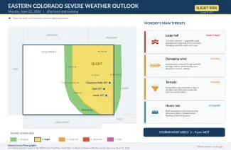
The same pattern is expected to deliver another round of storms Monday. The Storm Prediction Center has placed the eastern plains and the Interstate 25 corridor from Denver to Pueblo in a slight risk for severe weather — level 2 on its five-step scale. Storms should develop early in the afternoon over the higher terrain near the Palmer Divide, then move east and southeast and strengthen as they reach the more humid air toward the Colorado-Kansas border, continuing into the evening.
Large to very large hail is again the main concern, with localized damaging winds and a tornado or two also possible. Highs will be a touch cooler than recent days, in the 80s to low 90s — near 83 at Cheyenne Wells, 85 at Eads and 87 at Lamar. As of early Monday, no severe thunderstorm or tornado watches had been issued; those are typically posted a few hours before storms develop.
©
The Storm Prediction Center's severe weather outlook for Monday, June 22, 2026. (Kiowa County Press)
Fire weather and the week ahead
Away from the storm threat, a red flag warning for critical fire weather is in effect from 1 to 8 p.m. Monday over the western mountains and the San Luis Valley, and the National Weather Service in Pueblo has posted a fire weather watch for Tuesday afternoon. The storm-prone pattern over the eastern plains is forecast to continue through about Wednesday, with daily afternoon and evening thunderstorms, some of them severe. A change in the pattern is expected later in the week, which could bring either more widespread rain or stronger winds and renewed fire-weather concerns, depending on the storm track.
Staying safe
A severe thunderstorm or tornado watch means conditions are favorable for dangerous storms to develop over the next several hours — a signal to stay alert and know where you would take shelter. A warning means a dangerous storm is happening or imminent in your area, and you should act right away. Make sure you have a reliable way to receive warnings, such as a NOAA Weather Radio or alerts on your phone, and do not count on hearing an outdoor siren from indoors.
Large hail is the primary danger again Monday, and the safest place is indoors, away from windows. If a warning is issued and you are outside, protect your head and seek sturdy shelter. If you can hear thunder, lightning is close enough to strike, so stay inside until at least 30 minutes after the last rumble. Drivers should slow down in heavy rain, watch for sudden wind gusts and blowing dust, and never enter a flooded roadway. Before storms arrive, secure loose outdoor items, move vehicles under cover where possible, and check on neighbors, livestock and pets. All storm reports are preliminary and may be revised; the latest watches, warnings and timing are available at weather.gov.


