Warming trend, late-day storm chances for Cheyenne Wells

Kiowa County Press Staff
(Kiowa County Press)
Cheyenne Wells will warm through the weekend under mostly sunny skies, with highs near 90 Friday climbing into the mid 90s by Sunday, though slight chances for afternoon and evening thunderstorms linger Friday in Cheyenne County before hotter, breezier weather builds next week.
Friday is sunny in the Cheyenne Wells area with a slight chance of afternoon thunderstorms and highs around 90. West winds of 5 to 15 mph turn to the north at 10 to 15 mph in the afternoon. A slight chance of evening thunderstorms continues Friday night under mostly clear skies, with lows in the mid 50s and east winds up to 10 mph. The chance of precipitation is 20 percent both day and night.
Forecasters in Goodland highlighted the warming signal, citing an “increasing signal for above normal temperatures this weekend and into early next week” in Friday’s Area Forecast Discussion, written by a meteorologist with the National Weather Service forecast office in Goodland, Kan. The office said hot, windy and dry conditions are likely to follow by midweek.
Warm-up and midweek fire weather
A broad southwest flow aloft will support a steady warm-up, with highs reaching the mid 90s Sunday. Storm chances return Sunday evening through Monday, but forecasters said weak wind shear should limit organization, with small hail and gusty winds the main concerns from any storms.
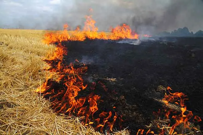
By Tuesday through Thursday, the weather service expects critical fire weather conditions across the region as highs climb into the upper 90s and beyond, winds gust 25 to 40 mph and relative humidity falls into the teens.
Cheyenne Wells, Colo. — Five-day forecast (June 5–9, 2026)
Source: National Weather Service, Goodland, Kan. — Issued June 5, 2026
| Period | Sky Conditions | High / Low | Wind |
|---|---|---|---|
| Friday | Sunny; slight PM t-storm chance | ~90° | W 5–15 mph, N 10–15 mph PM |
| Friday night | Mostly clear; slight t-storm chance | ~55° | E up to 10 mph |
| Saturday | Increasing clouds | 90–93° | S to SE 10–20 mph |
| Saturday night | Mostly clear | ~55° | SE 10–20 mph |
| Sunday | Sunny | ~95° | S 10–20 mph |
| Sunday night | Mostly clear | 57–59° | — |
| Monday | Mostly sunny; slight PM t-storm chance | 90–93° | — |
| Monday night | Mostly clear; slight t-storm chance | 57–59° | — |
| Tuesday | Partly cloudy, then clearing; hot | 96–99° | Breezy |
| Tuesday night | Decreasing clouds; windy | 60–63° | Windy |
(Kiowa County Press)
Saturday and Sunday
Saturday brings increasing clouds with highs in the lower 90s and southeast winds of 10 to 20 mph by afternoon. Skies turn mostly clear Saturday night with lows in the mid 50s. Sunday is sunny and warmer, with highs in the mid 90s and south winds of 10 to 20 mph.
Extended outlook
Monday is mostly sunny with a slight chance of afternoon thunderstorms and highs in the lower 90s. Tuesday turns breezy and hot as skies clear, with highs in the upper 90s, followed by a windy Tuesday night. Forecasters expect hot, dry and windy weather — and rising fire danger — to dominate the rest of the week.
With fire danger expected to climb midweek, residents are encouraged to use caution with any potential ignition sources, particularly during the windy afternoons.