Arkansas River Report – March 2024
March precipitation brought above-normal snowpack to all of the state's river basins, leaving less than 30 percent of Colorado under any level of drought conditions, according to the latest U.S. Drought Monitor report released April 4. The National Weather Service three-month outlook "leans" toward above-average temperatures for Colorado and the Arkansas River Basin through June and projects "equal chances" of normal precipitation for all but the northeastern corner of the state, which could see above-normal precipitation.

©
Snowpack
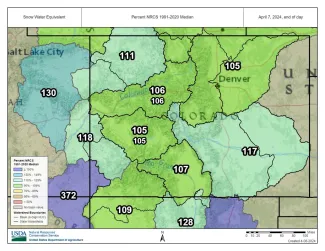
The latest data available from the Natural Resources Conservation Service shows snowpack in the Arkansas Basin at 117 percent of median (reported as snow-water equivalent). Snowpack Telemetry (SNOTEL) stations around the Arkansas Basin report snowpack ranging from 93 percent of median at South Colony to 391 percent at Medano Pass. (Both stations are in the Sangre de Cristo Range.) Additional SNOTEL readings are:
- 235 percent at Apishipa west of Trinidad.
- 212 percent at Glen Cove near Pikes Peak.
- 120 percent at Rough and Tumble in the Mosquito Range.
- 118 percent at Brumley near Independence Pass.
- 113 percent at Hayden Pass in the northern Sangre de Cristos.
- 110 percent at St. Elmo in western Chaffee County.
- 99 percent at Fremont Pass north of Leadville.
Reservoir Storage
The Bureau of Reclamation website indicates Pueblo Reservoir is 78.5 percent full with 253,644 acre-feet of water in storage, slightly less than was reported at the end of February. At 63.2 percent full, Turquoise Lake currently stores 81,821.6 acre-feet of water compared to 78,306 acre-feet a month ago. Twin Lakes, 72.5 percent full, currently impounds 97,509.5 acre-feet of water, down from 102,200 acre-feet at the beginning of March. The U.S. Army Corps of Engineers reports water storage in John Martin Reservoir at 61,396 acre-feet, up from 52,454 acre-feet a month ago.
River Flows
From April 1 to May 15, the Voluntary Flow Management Program sets a target of 250-450 cfs for Arkansas River flowsat the Wellsville gauge, which currently reports 262 cfs. The Leadville gauge currently reports "No data for last 7 days." The gauge below Granite reads 151 cfs. River flow at Cañon City is currently 305 cfs. With the start of irrigation season, river flow below Pueblo Reservoir has jumped from 86 cfs last month to a current reading of 537 cfs, and the flow at near Avondale almost tripled, from 349 cfs to 1030 cfs. The gauge near Rocky Ford reads 303 cfs, below John Martin Reservoir, 120 cfs. The flow near Lamar is 9.69 cfs.
Calling Water Rights
Seven water rights are calling for water in the Arkansas Basin, along with two authorized diversions. The most senior calling right is the Chilili Ditch with an 1862 priority date on the Purgatoire River. The 1866 Gonzales Ditch right on the Apishipa River is next in priority, followed by the 1867 Garcia Ditch No. 2 on the Huerfano River. Other calling rights are:
- 1884, Lake Mirriam Ditch, Cucharas River.
- 1885, Buffalo Canal, Arkansas River mainstem.
- 1886, Cascade Ditch, Hardscrabble Creek.
- 1887, Fort Lyon Canal, Arkansas River mainstem.
The two authorized diversions are the Welton Ditch, on the Huerfano River (1889 priority) and John Martin Reservoir on the Arkansas mainstem (1949).


