Another hot day: Eads forecast raised to potential record-breaking 106 Sunday

The National Weather Service has raised its Sunday forecast for Eads and Lamar above what it expected a day earlier, and the new figure for Eads would exceed the town's record for the date if it verifies.
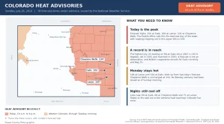
The Pueblo office is calling for 106 degrees at Eads, up from the 105 in the forecast the Press reported Saturday. Lamar rose from 107 to 109. Cheyenne Wells is unchanged at 104. Overnight lows are forecast at 69 degrees at Eads, 68 at Cheyenne Wells and 71 at Lamar.
©
A heat advisory issued at 1:46 a.m. Sunday runs from 10 a.m. to 9 p.m. and covers nine forecast zones, among them both western and eastern Kiowa County, along with Otero, Bent and Prowers counties. Because that single advisory now spans everything from Canon City and the Rampart Range down to the lower Arkansas River Valley, its stated range is correspondingly broad: “temperatures of 96 to 109 expected.” Saturday's separate Kiowa County advisory had read “temperatures of 100 to 105 expected.” Separate advisories cover Crowley County and Baca County, each calling for 100 to 105 degrees. The advisory warns that “hot temperatures may cause heat illnesses” and repeats the guidance to drink fluids, stay in air conditioning, stay out of the sun and check on relatives and neighbors.
What the record actually says
The federal cooperative climate record at Eads begins in April 1907 and includes 107 years with a July 26 reading. The highest of them is 102.9 degrees, reached in 1931 and matched in 2003. Sunday's forecast of 106 would pass that mark.
Two cautions belong with that. The first is that a forecast is not an observation. The second is that no official reading is available to settle it: NOAA's cooperative observations for Eads currently on file end May 31, so the station that holds the record is not reporting the day that might break it. For scale, the Eads record contains 965 days at or above 100 degrees and 85 at or above 105 in nearly 120 years. The hottest readings on file there are 110 degrees, in June 1963 and July 1947.
Forecasters expect the warmest day of the week
The Pueblo office's area forecast discussion, issued at 5:28 a.m. Sunday, carries forward text written by the overnight shift at 12:47 a.m. It says “dangerously hot temperatures are expected underneath the ridge again today, with likely the warmest readings of the week expected across region,” with highs that “top out in the upper 90s to 109F, warmest across the lower Arkansas River Valley.”
The discussion also notes that “we could also see a few records fall today, with current record max temperatures for July 26th being 91F for ALS in 2023, 97F for COS in 1953, and 103F for PUB in 2023.” Those are Alamosa, Colorado Springs and Pueblo. Eads is not among the stations the office listed.
Saturday ran above the forecast at Lamar
Lamar Municipal Airport reached 106 degrees at 5 p.m. Saturday, two degrees above the 104 that had been forecast for the day. Elsewhere in the region, La Junta Municipal Airport reached 104 at 3:50 p.m., Burlington 102 at 4:45 p.m. and Springfield 100 at 3:15 p.m. Forecast figures for those three are not on file for comparison.
The Press's own weather station at Eads recorded a high of 106.8 degrees at 3:05 p.m. Saturday and a low of 67.5, on a complete set of 288 five-minute samples flagged valid. It read 104.7 degrees Friday and 105.8 on July 20. That station is not a NOAA climate observation and its readings cannot be set against the cooperative station's records, which use different equipment, siting and observation conventions. It has not logged a full day for Sunday.
The days ahead
Monday's forecast rose at two of the three towns: 108 degrees at Lamar, up from 107, and 104 at Eads, up from about 102. Cheyenne Wells is unchanged at 102. No heat advisory had been issued for Monday as of Sunday morning; the overnight discussion said forecasters would “let the next shift get a better handle on temperatures and the need for any Heat Advisories for Monday.”
©
Highs are forecast to ease after that — 96, 95 and 97 degrees at Eads Tuesday through Thursday, 93, 93 and 95 at Cheyenne Wells, and 100, 99 and 100 at Lamar. Among the office's key messages is that monsoonal moisture increases areawide through the end of the work week, “with increasing coverage of daily showers and storms bringing increased flash flooding concerns, especially for burn areas,” followed by a drying trend into next weekend.
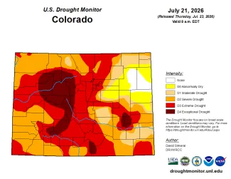
The heat is building on ground already short of water. The most recent U.S. Drought Monitor, released Thursday, put 20 percent of Kiowa County in exceptional drought, the most severe category, with another 32 percent in extreme drought. Rainfall at Eads for July stands at 0.95 inches through Sunday, against a long-term July average of 2.60 inches.
The heat has deepened east of Colorado
Colorado had eight heat advisories in effect Sunday morning and no extreme heat warnings. The picture beyond the state line is different and has changed materially since Saturday. Kansas went from three extreme heat warnings to eight, Nebraska from five to nine and South Dakota from two to five. Missouri had 10 and Iowa seven. Across Colorado and 13 other states from the Rockies to the lower Mississippi Valley, 49 extreme heat warnings, 64 advisories and nine watches were in effect. The highest heat index cited in any Kansas product was 116, in the northeast corner of that state.
Cheyenne County is covered by the Goodland office rather than Pueblo, under an advisory that also takes in Kit Carson and Yuma counties and calls for heat index values up to 105. Forecasters there wrote that lows in the upper 60s to low 70s Saturday night and into Sunday morning were forecast to “further exacerbate any heat related impacts for the day Sunday.”
Heat safety guidance, the signs separating heat exhaustion from heat stroke, livestock panting scores and Colorado's agricultural heat rules were covered in detail in Saturday's article and are not repeated here.
Current watches, warnings and advisories are available at weather.gov.