Colorado's warmest water year on record ends with most of the state still in drought

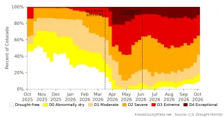
The water year that ended September 30 was the warmest in Colorado's 131 years of records, by a wide margin, and one of the driest. It began with nearly half the state free of drought. It ended with 82 percent of Colorado in drought, a tenth of the state still in the worst category, reservoirs lower than a year ago in every basin but one, and a statewide drought emergency still on the books.
©
The water year runs from October 1 to September 30, the way water managers count the seasons: snow piles up through the winter, melts in spring, and runs the rivers and fills the reservoirs through summer. This year the pattern broke at every step.
A warm start
On the last U.S. Drought Monitor map before the water year began, September 30, 2025, 46 percent of Colorado had no drought at all. Only 14 percent was in extreme drought, and none was in the worst category, exceptional drought. Kiowa County was entirely drought-free and stayed that way into March.
© iStock - Xurzon
Then the heat came. October was the 11th warmest on record statewide, November the third warmest, and December the warmest ever, according to the Colorado Climate Center at Colorado State University. February and March set records too. By the end of March the state had logged its warmest start to a water year in 131 years.
The snow did not come with the warmth. March was the second driest March on record. Snowpack across the state peaked in early March, a month early, at 51 percent of the median, according to the Water Conditions Monitoring Committee. The committee, convened by the Colorado Water Conservation Board, meets monthly to hear from the state climatologist's office, the Natural Resources Conservation Service, the Division of Water Resources and other specialists on snowpack, streamflow, reservoirs and the seasonal outlook.
The task force
On March 16, Governor Jared Polis activated Colorado's Drought Task Force and moved the state into Phase 2 of its Drought Response Plan. The task force, last called up in 2020, brings together the heads of the Department of Natural Resources, the Department of Agriculture, the Department of Local Affairs, and the Division of Homeland Security and Emergency Management.
"Colorado is experiencing the warmest year so far in our 131-year record, and one of the driest," Polis said at the time. "Activating the Drought Task Force will help ensure we are protecting one of our most precious resources by closely tracking impacts, supporting communities, and coordinating better as we prepare for the year ahead."
The Drought Response Plan is part of the state's hazard mitigation plan, maintained by the Division of Homeland Security and Emergency Management with the water board leading the drought sections. Phase 2 convenes the task force. Phase 3 adds a formal drought emergency declared by the Governor, which under state law runs 30 days at a time and can be extended.
The task force does not control water or hand out money on its own. Its job is to gather what is happening on the ground across the state, raise those impacts to the Governor's office, and coordinate the agencies that do have programs and funding. It met monthly through the spring and summer, in April, May, June, July and August, with work groups on municipal impacts, agricultural impacts, and wildfire risk.
"Drought does not impact every community in the same way," said Lauren Ris, director of the Colorado Water Conservation Board, in March. "The Drought Task Force helps the state understand where impacts are being felt the most."
The bottom falls out
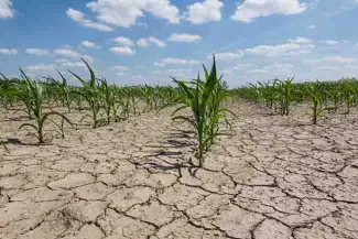
April made the year. On March 31 the Drought Monitor recorded no drought-free ground anywhere in Colorado for the first time, and it stayed that way for 12 straight weeks. By April 21 statewide snow water equivalent was 19 percent of the median, the lowest on record, and 90 percent of the state was in severe drought or worse. In the Arkansas basin, snowpack stood at 10 percent of the median.
That same week exceptional drought, the Drought Monitor's worst category, covered 22 percent of Colorado, its peak for the year. A week later, extreme or exceptional drought covered 58 percent of the state, the high mark of the water year. Streamflow forecasts issued May 1 projected runoff of 21 to 37 percent of median across the state's river basins.
© iStock - Taglass
On June 4, Polis activated Phase 3 of the drought plan and declared a statewide drought emergency. Every one of the state's 64 counties was at least abnormally dry, and 93 percent of Colorado was in moderate drought or worse.
"Today I am issuing a statewide drought emergency to support Coloradans, our economy, farmers and ranchers, and outdoor enthusiasts in the face of one of the most severe droughts in Colorado's recorded history," Polis said.
Phase 3 lets the state take steps Phase 2 does not: emergency funding for needs that other programs cannot meet, and cuts to outdoor water use at state facilities. Under Phase 3, requests for help must be tied to specific needs and go through the task force before reaching the Governor. The state's own plan notes that no president has ever issued a disaster declaration for drought. Federal drought help comes instead through the Department of Agriculture and the Small Business Administration.
Summer on the plains
Southeast Colorado had come through the winter better than the mountains. That changed in late spring. Kiowa County entered severe drought the week of April 14, extreme drought the week of May 26 and exceptional drought the week of June 23. By July 28, 36 percent of the county was in exceptional drought. On August 4, 33 of Colorado's 64 counties carried some exceptional drought, including Kiowa, Bent, Otero, Crowley, Lincoln, Las Animas and Pueblo.
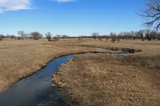
South fork of the Republican River in Hale, Colorado - CC4.0 - Jeffrey Beall - Wikimedia Commons
Rivers told the same story. Statewide streamflow from April through July was 28 percent of the median, and August ran at 26 percent, the Natural Resources Conservation Service told the monitoring committee September 22. Many gauges set new record lows. In the Arkansas basin, the river above Pueblo Reservoir carried 9 percent of its median April-through-July flow, and inflow to the reservoir from April through August was 8 percent of normal. Below John Martin Dam, less water passed downstream this water year than in any year in 88 years of records, as the Press reported in September.
The dry ground burned. At the task force's July 23 meeting, the Division of Fire Prevention and Control counted 13 large wildfires burning in the state, with more than 100 crews, nearly 400 engines and 45 helicopters assigned. The Aspen Acres fire southwest of Pueblo had burned more than 100,000 acres.
What the task force asked for
By July the task force had turned to what the Governor could do by executive order. At its July 23 meeting it advanced four ideas: identify landscaping at state facilities that could use less water, require state facilities above a certain size to write water-efficiency and drought-response plans, wash state vehicles less often, and temporarily extend state tax deadlines for small businesses hurt by the drought. On August 24 the task force said it would finalize a memo to the Governor with those recommendations.
As of October 2, no drought order had appeared among the executive orders posted by the Governor's office, and the task force had not met since August 24. The June 4 emergency declaration had not been lifted.
Federal help for farms and businesses
Federal help arrived county by county, and Kiowa County's turn came last week. The U.S. Department of Agriculture issues a drought disaster designation for a county once any part of it has been in severe drought for eight straight weeks, or in extreme or exceptional drought at all, during the growing season. A designation opens Farm Service Agency emergency loans to farmers and ranchers in that county and in every county that touches it, with eight months to apply. The loans can replace equipment or livestock, reorganize an operation, or refinance certain debts.
Colorado received 16 such designations between April 6 and May 19. The largest, issued April 6, named 33 counties from the Front Range and mountains as primary disaster areas, as the Press reported at the time. Southeast Colorado followed as the drought moved east. On April 29, Otero, Kit Carson, Elbert and Washington counties were named primary areas, which made Kiowa, Cheyenne, Bent, Crowley, Lincoln and Las Animas counties eligible as neighbors. On May 18, Bent and Prowers counties became primary areas.
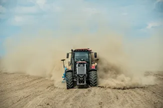
On September 23, the Department of Agriculture named Kiowa County a primary disaster area in its own right, along with Cheyenne, Crowley, Fremont and Morgan counties, according to the Farm Service Agency's list of designations. Bent, Kit Carson, Lincoln, Otero and Prowers counties are eligible as neighbors under that designation. Producers have until March 29, 2027, to apply, and can start at their local USDA Service Center. Deadlines under the spring designations run from December 7 to December 24.
The Small Business Administration follows each USDA designation with a declaration of its own, for businesses that depend on farm income but are not farms. Its Economic Injury Disaster Loans are open to small businesses, small agricultural cooperatives, nurseries and private nonprofits with losses tied to the drought. Farmers and ranchers themselves are not eligible. The loans run up to 2 million dollars at 4 percent interest for businesses and 3.625 percent for nonprofits, over terms up to 30 years, with no payments for the first year.
Two Colorado declarations issued in April and May covered 52 counties, including Baca, Bent, Crowley, Kit Carson, Lincoln and Otero, with applications due December 7 and December 24. A third, issued June 1, covers Kiowa, Baca, Bent, Las Animas, Otero and Prowers counties, along with Greeley, Hamilton and Stanton counties in Kansas, for losses from a drought the agency dates to April 28. Applications under that declaration are due January 19, 2027, at sba.gov/disaster or by phone at 800-659-2955.
The record books
When the Water Conditions Monitoring Committee met September 22, state climatologist Russ Schumacher laid out the year's superlatives. December, February, March and August were each the warmest on record statewide. Winter, spring and summer were each the warmest of their season in 132 years of records. The water year as a whole finished 5.6 degrees warmer than the 1971 to 2000 average and 1.8 degrees warmer than the previous record, set in 1934. September, he said, was also in the running for the warmest on record.
October through August was the sixth driest such stretch on record statewide, with no part of the state unusually wet. At the end of August the Palmer Drought Severity Index, a long-running measure that weighs heat and dryness together, was the lowest Colorado had recorded, slightly worse than 2002.
The Natural Resources Conservation Service reported statewide reservoir storage at 38 percent of capacity and 56 percent of median on September 1, lower than a year earlier in every basin except the South Platte. The Gunnison basin fell from 60 percent of median to 35, and the Colorado headwaters from 81 to 45. Blue Mesa Reservoir, the state's largest, accounted for most of the Gunnison deficit. Water-year precipitation through September 22 stood at 80 percent of the median, at the eighth percentile of the record.
©
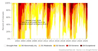
Measured by the average share of the state in severe drought or worse across the whole water year, 2026 ranks fourth among the 27 water years since the Drought Monitor began in 2000, behind 2003, 2013 and 2021. Measured by its worst week, it ranks seventh. What set this year apart was not how far the drought spread but how warm it was.
Relief, but not recovery
The monsoon arrived in July and rain fell across parts of the Eastern Plains in August. Kiowa County lost its last exceptional drought on the September 1 map, and by September 8, 6 percent of Colorado was drought-free again for the first time since March. Then September turned wet. The Press's weather station in Eads recorded 2.36 inches of rain from September 19 through September 28, and statewide September precipitation had reached 167 percent of normal by September 22, with a rain of 2.85 inches in a day near Ignacio counted as a greater-than-100-year event. The remnants of Hurricane Polo soaked southern and eastern Colorado in the water year's final days.
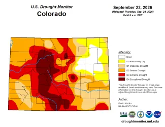
The Drought Monitor's final map of the water year, valid September 29, showed 58 percent of Colorado in severe drought or worse, 35 percent in extreme drought or worse, and 10 percent in exceptional drought. Nine percent of the state was drought-free. A year earlier the figures were 36 percent, 14 percent, none and 46 percent.
©
The plains fared best. Kiowa County left severe drought entirely on the September 29 map, with 77 percent of the county in moderate drought and the rest abnormally dry or clear. Cheyenne County was 71 percent drought-free, and Bent, Crowley and Prowers counties were no worse than moderate drought. Baca County still had 46 percent of its area in severe drought, and Pueblo and Las Animas counties each had about a quarter in extreme drought. Twenty-five counties still carried exceptional drought, nearly all of them in the mountains: all of Eagle County, 88 percent of Summit County and 80 percent of Pitkin County.
Soils have taken in the rain. The Natural Resources Conservation Service found soil moisture above median in most major basins by September 22, after a prolonged summer deficit. But the agency's summary of where the state stands was blunt: Colorado is approaching the new water year with depleted storage, and the snowpack season does not usually begin until late October.
What comes next
The forecast for the new water year rests on the Pacific Ocean. On September 10 the federal Climate Prediction Center kept its El Niño Advisory in place and said the event is still strengthening, with sea-surface temperatures in the key Pacific region running 1.8 degrees Celsius above normal. The center put the odds of a very strong El Niño this fall and winter above 90 percent, and gave a 75 percent chance that it becomes the strongest on record, going back to 1950. The next update comes October 8.
"With an event of this magnitude, the chances of experiencing impacts consistent with El Niño are larger, though not guaranteed," the center wrote.
For Colorado, El Niño usually means a wetter year, and the effect is strongest in fall and spring, according to Peter Goble, assistant state climatologist at the Colorado Climate Center, in a September 3 analysis the Press reported on last month. The Front Range and Eastern Plains are more prone to big spring snowstorms in El Niño years and see fewer of the dry, windy spring days that pull moisture from the soil.
But Goble cautioned that a stronger El Niño does not promise a bigger payoff. Of the three super El Niños on record, 1982-83 brought huge snowfall to Colorado, while 1997-98 and 2015-16 delivered roughly average conditions. The link between El Niño and peak snowpack in Colorado is weak, he wrote, except for a loose positive tie in the southern basins such as the San Juan and Rio Grande. And the state is warmer than it was in those years, so more of what falls may come as rain rather than snow, especially at lower elevations.
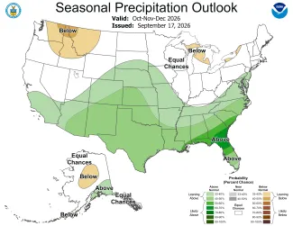
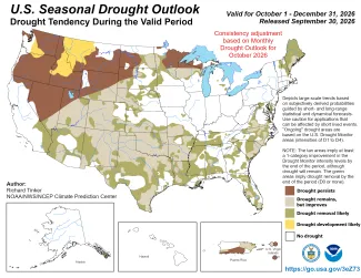
The federal outlooks issued September 17 lean the same way. The Climate Prediction Center's outlook for October through December tilts toward above-normal precipitation across the Four Corners and the central and southern Plains, with the winter outlook for December through February favoring a wetter-than-normal southern tier. Its seasonal drought outlook, reissued September 30 to run through December, expects drought to persist or intensify across the northern Rockies and the northern Plains, where the forecasts show no wet signal. For Colorado the picture is improvement: drought remains but eases across most of the state, mountains included, and removal is likely along the Arkansas valley and parts of the eastern plains. The center's outlook for October alone, issued the same day, draws the same line at the Wyoming border.
©
©
Even a wet fall will not refill what the winter took. Reservoir storage statewide is at 56 percent of median, Blue Mesa remains near record lows, and the Arkansas River has finished its lowest water year on record above Pueblo. "Nothing is guaranteed," Schumacher wrote in June, noting that El Niño's pull on Colorado weather is weaker than in the states around it.
The Natural Resources Conservation Service publishes its first water supply report of the new water year in early October, NOAA's winter outlook comes October 15, and the Water Conditions Monitoring Committee meets again November 17. The drought emergency remains in effect.