Flood Watch for much of Colorado as hurricane moisture soaks the Southwest and Plains

Moisture from Hurricane Polo and a second, weaker Pacific storm is spreading heavy rain from Arizona to the Great Plains this week. All of Kiowa County is under a Flood Watch from 6 a.m. Tuesday until noon Thursday.
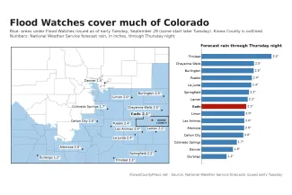
The National Weather Service forecast for Eads adds up to about 2 inches of rain by Thursday night. The heaviest rain is expected late Tuesday night and Wednesday. Forecasters in Pueblo warn the total could be much lower if the storm takes a more eastern track.
What to expect in Kiowa County
The Pueblo office's watch covers the southeast plains, including Kiowa, Crowley, Otero, Bent, Prowers and Baca counties and eastern Las Animas County. It also covers Pueblo and the mountains and valleys to the west and southwest, from Cañon City to Walsenburg and Trinidad.
"Periods of heavy rainfall associated with a remnant tropical storm system will spread across southern Colorado Tuesday through Thursday," the watch says. Creeks and streams may rise out of their banks, and low spots may flood.
The weather service forecast for Eads, as of early Tuesday:
- Tuesday: Rain showers likely, with a high near 67. A tenth to a quarter of an inch of rain.
- Tuesday night: Showers and thunderstorms. A half to three-quarters of an inch.
- Wednesday: Showers and thunderstorms, with a high near 64. Three-quarters of an inch to an inch. Northeast wind gusts as high as 40 mph.
- Wednesday night: Showers and thunderstorms. A quarter to a half inch. North wind gusts as high as 45 mph.
- Thursday: Showers and thunderstorms, with a high near 61. A tenth to a quarter of an inch. Gusts as high as 50 mph.
- Friday: Sunny, with a high near 65.
The Weather Prediction Center rates the risk of flooding rain in most of Kiowa County at level 2 of 4 through Thursday. Eastern Kiowa County, around Sheridan Lake, is at level 3 from Tuesday morning into early Wednesday.
Forecasters are not sure how the storm will track. In their early Tuesday discussion, they described two possibilities. The wetter one brings 2 to 4 inches to the central and southern Interstate 25 corridor and the Raton Mesa. The drier one brings a half inch or less in many places. Near the Kansas border, it brings up to about an inch and a half, along with strong north winds.
The official forecast leans toward the wetter side, with 1 to 3 inches, mostly along and south of U.S. Highway 50. But if the storm tracks farther east, forecasters wrote, "rainfall amounts could be significantly less!"
©
Either way, the rain ends by Thursday night. Dry, warmer weather follows, with highs in Eads near 70 from Saturday through Monday.
Eads has already had a wet stretch. The Press' weather station in Eads recorded 2.36 inches of rain from September 19 through September 28, including 1.44 inches on September 24.
The U.S. Drought Monitor released September 24 shows no extreme drought left in Kiowa County. A week earlier, extreme drought covered about a fifth of the county. Most of the county is still in severe drought. That map counts rain only through the morning of September 22, so the September 24 rain will first show up in the map due Thursday, October 1.
Across Colorado
Flood Watches cover much of southern and eastern Colorado.
- The Pueblo office's watches also cover the San Luis Valley through Wednesday evening and the eastern San Juan Mountains through early Wednesday. Colorado Springs and Teller County are under a watch from noon Tuesday to noon Thursday.
- The Grand Junction office has a watch for southwest Colorado, including the Animas, San Juan and Dolores river basins, through early Wednesday.
- The Denver/Boulder office's watch covers the southern Front Range foothills, the Palmer Divide, and Elbert and Lincoln counties from midnight Tuesday night to noon Thursday. It calls for 1.5 to 3 inches of rain, with more than 4 inches possible in spots.
- The Goodland, Kansas, office's watch covers Cheyenne, Kit Carson and Yuma counties from 6 p.m. Tuesday to 6 p.m. Thursday. It calls for a half inch to 2 inches, with isolated amounts near 4 inches.
Of the Colorado towns the Press checked, Trinidad has the highest forecast total, at about 3.3 inches through Thursday night.
The Pueblo watch names the Aspen Acres burn area in the southeast mountains. Burned ground can't absorb rain, so the water collects or runs across the surface toward low spots, according to the weather service. In August, flooding in that area killed a man in Beulah, the Press reported.
No Colorado river was forecast to reach flood stage as of the weather service's latest river forecasts. In the mountains, several inches of snow are possible on the highest peaks, above about 12,000 feet.
The rain has already started in southwest Colorado. Weather stations recorded 1.75 inches at Wolf Creek Pass, 1.34 inches at Pagosa Springs and 0.97 inch at Durango on Monday. Flooding closed County Road 500 near Arboles in Archuleta County Monday afternoon.
A storm fed by a hurricane
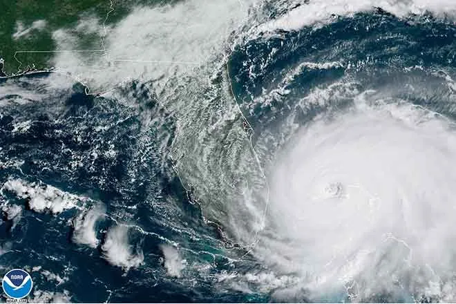
Polo came ashore on Mexico's Baja California peninsula late Monday as a Category 2 hurricane with winds near 110 mph, the National Hurricane Center said. By 3 a.m. Tuesday, Colorado time, its winds had dropped to 80 mph.
Polo was expected to reach the Mexican state of Sonora late Tuesday morning, possibly still as a hurricane, and then weaken quickly. What is left of it is expected to merge with a strong storm system over the Four Corners on Tuesday and Wednesday. Polo was a Category 5 hurricane last week, with winds as high as 180 mph.
Odalys, a former hurricane, stayed far out at sea and lost its tropical status Sunday. The hurricane center said distant moisture from it would also reach the Southwest and may add to the heavy rain.
The air is unusually wet. A weather balloon launched Monday evening by the weather service's El Paso office found about 250 percent of the normal moisture for the date. That is well above the record for that day, the office said. In its Flood Watch for New Mexico, the Albuquerque weather office warned of "a near-record to record surge of moisture."
The Weather Prediction Center put a large area from south-central Arizona to southwest Kansas at a moderate risk of flooding rain Tuesday. That is the third of four levels. The center singled out an area from central New Mexico to southern Colorado, including the Sangre de Cristo Mountains and nearby corners of Texas and Oklahoma, as "the area most likely to experience locally catastrophic flooding." It expects 2 to 4 inches of rain there, locally more.
On Wednesday, the moderate risk covers southern Colorado and northern New Mexico, including Lamar and Pueblo, plus parts of Oklahoma and Texas. On Thursday, it shifts to southeast Oklahoma and central and south Texas.
Early Tuesday, Flood Watches stretched from Arizona and Utah east across New Mexico, Colorado, Texas, Oklahoma and Kansas, and north into Nebraska, Iowa and Missouri.
Flash flooding hit several places Monday, according to weather service storm reports. Water ran through canyons across Zion National Park in southern Utah. Flooding closed several roads in Colorado City, Arizona, and in the California desert near Needles. Water and mud flowed across streets in Laughlin, Nevada, and Bullhead City, Arizona, where one high-water rescue from a submerged vehicle was reported.
Yuma, Arizona, got 0.30 inch of rain Monday, breaking the day's record of 0.28 inch set in 1905, the weather service said.
No deaths from the storm had been reported in the United States as of early Tuesday. In Mexico, two children, ages 3 and 12, died over the weekend when a flash flood linked to Polo's rains swept away their family's home in Talpa de Allende, in the state of Jalisco. Jalisco Governor Pablo Lemus announced the deaths, and the children's parents were missing, according to news reports.
Staying safe
The weather service asks people under the watch to keep an eye on later forecasts and be ready to act if a Flash Flood Warning is issued. Never drive or walk through water over a road. Just 6 inches of fast-moving water can knock over an adult, and 12 inches can carry away most cars, according to the weather service. More flood safety tips are at weather.gov/safety/flood.