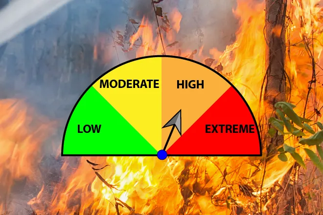
Lamar under red flag warning Friday; weekend storms expected to cool southeast plains

Prowers County is included in a red flag warning in effect until 9 p.m. Friday as Lamar and the rest of the southeast plains face south winds gusting to 35 mph, highs near 81 and relative humidity as low as 6 percent, the National Weather Service in Pueblo said. Cooler weather, widespread showers and thunderstorms are expected Saturday night through Sunday as a cold front ends the run of dry, windy conditions.
Lamar is forecast to see the warmest temperatures of the three southeastern Colorado hub towns Friday, with a high near 81 under sunny skies and south winds of 15 to 20 mph gusting as high as 35. The combination of warm air, strong winds and low humidity places Prowers County squarely in the red flag warning area through 9 p.m. Friday night brings mostly cloudy skies, a low around 39 and continued south winds of 15 to 20 mph with gusts to 35.
"Critical fire weather conditions have developed over portions of the high country as of 11 AM, and are expected to spread out towards the plains as winds increase over the lower elevations," meteorologists with the Pueblo forecast office wrote in Friday's Area Forecast Discussion.
Fire weather concerns Friday
Prowers County (fire weather zone 236) is explicitly included in the red flag warning issued by the Pueblo forecast office for gusty winds and low relative humidity. The warning covers all of the Pueblo office's southeast zones from 221 through 237 and runs through 9 p.m. Friday. Saturday's red flag warning is confined to the San Luis Valley, the Upper Arkansas River Valley and areas near the Interstate 25 corridor; Prowers County is not included in Saturday's warning. Outdoor burning should be avoided through Friday evening, and drivers should take care to keep vehicles off dry grass.
Lamar, Colo. — Five-day forecast (April 24–28, 2026)
Source: National Weather Service, Pueblo — Issued April 24, 2026
Period | Sky Conditions | High/Low | Wind |
|---|---|---|---|
| Friday | Sunny | High 81 | South 15–20 mph, gusts 35 mph |
| Friday night | Mostly cloudy | Low 39 | South 15–20 mph, gusts 35 mph |
| Saturday | Sunny | High 71 | North-northeast 15 mph |
| Saturday night | Showers and thunderstorms likely | Low 42 | East 10–15 mph |
| Sunday | Showers and thunderstorms likely | High 77 | South-southeast 10–20 mph, gusts 35 |
| Sunday night | Chance storms; partly cloudy | Low 41 | West 10–20 mph, gusts 35 mph |
| Monday | Sunny; slight chance storms | High 72 | North-northwest 10–15 mph |
| Monday night | Slight chance storms | Low 33 | East-northeast 10–15 mph |
| Tuesday | Sunny | High 78 | Southeast 10–15 mph |
| Tuesday night | Partly cloudy | Low 39 | East 10–20 mph |
(Kiowa County Press)
Weekend storm chances
A cold front is expected to move across southeast Colorado late Friday night, switching winds to the north and dropping Saturday highs into the lower 70s at Lamar. Saturday itself should stay dry with sunny skies and north-northeast winds around 15 mph, but rain showers become likely after midnight with a 60 percent chance of precipitation.
Sunday brings a 70 percent chance of showers and thunderstorms with a high near 77 and south-southeast winds at 10 to 20 mph, gusting to 35. Rainfall amounts are expected to be light, generally less than a tenth of an inch. Rain chances wind down Sunday night as westerly winds of 10 to 20 mph and gusts to 35 usher in drier air behind the system.
Monday and Tuesday outlook
Monday looks sunny with a high near 72, light north-northwest winds and a slight chance of afternoon showers or thunderstorms. Lows drop into the low 30s overnight. Tuesday warms to a high near 78 under sunny skies with light southeast winds. Pueblo forecasters said another round of critical fire weather is possible on Tuesday behind strong zonal flow, especially for locations that miss out on weekend rainfall.
Lamar-area residents should take fire-prevention steps seriously Friday, then watch for lightning, gusty outflow winds and possible blowing dust associated with the cold front and weekend thunderstorms.