Severe storms possible across the eastern Colorado plains Thursday

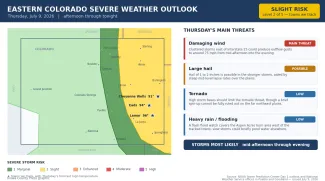
Forecasters expect strong to severe thunderstorms to develop across the eastern Colorado plains on Thursday afternoon and evening. The NOAA Storm Prediction Center has placed the eastern plains — including Kiowa, Cheyenne and Prowers counties — in a slight risk for severe storms, level 2 of 5. Damaging wind is the main concern, with large hail also possible and a low tornado threat.
Storms are expected to fire over the mountains shortly after midday, then push east and intensify across the plains through the afternoon and into the evening before departing near midnight. No severe thunderstorm watch was in effect early Thursday; any watches would be issued later in the day as storms develop. This article was prepared Thursday morning, and conditions may change as the day unfolds. Highs will reach the low-to-mid 90s — near 94 at Eads, 91 at Cheyenne Wells and 96 at Lamar.
At a glance: Thursday's severe weather risks
©
Source: NOAA Storm Prediction Center Day 1 outlook and National Weather Service offices in Pueblo and Goodland — issued the morning of July 9, 2026. Times are Mountain.
(Kiowa County Press)
What the Storm Prediction Center is saying
In its Thursday morning outlook, the Storm Prediction Center in Norman, Okla., placed most of the eastern Colorado plains — including Cheyenne Wells, Eads and Lamar — in a slight risk for severe storms, level 2 of 5, with a marginal risk, level 1, over the higher terrain to the west. Forecasters said the leading threat would be damaging wind from clustered storms, with hail of 1 to 2 inches possible in the strongest cells. Higher storm bases and limited low-level spin are expected to hold down the tornado threat across the region.
Timing and where the storms are most likely
The National Weather Service office in Pueblo, which covers the southeast plains including Kiowa, Prowers, Bent, Otero, Crowley and Baca counties, expects storms to first develop over the eastern mountains shortly after midday, then push east across the plains through the afternoon as a northerly surge increases low-level wind shear. Forecasters there said the environment looked favorable for a grouping of strong to severe storms capable of gusty outflow winds, hail and moderate to heavy rain, with instability increasing toward the Kansas border. The storms are expected to move out of the area before midnight. A flash flood watch is in effect from noon to 8 p.m. for the Aspen Acres burn area, west of the tracked towns, where slow-moving storms could drop heavy rain over scorched ground.
The Goodland, Kan., office, which covers Cheyenne, Kit Carson and Yuma counties, said storms should develop along the Front Range and Palmer Divide by mid-to-late afternoon and cluster into eastern Colorado around 5 to 6 p.m., moving steadily east into the night. Forecasters there said the storms would most likely be a wind threat given their clustered, linear mode, with the strongest gusts around 75 mph and hail up to about 2 inches possible. High cloud bases were expected to limit the tornado risk. The office listed no watches or warnings for its Colorado counties early Thursday.
What happened Wednesday
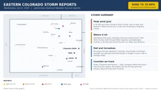
Wednesday's severe weather in Colorado was largely a wind story. The National Weather Service logged five severe wind gusts across the eastern half of the state, the strongest a 78 mph gust near Cheraw in Otero County, followed by 76 mph near Masters in Weld County and 72 mph near Strasburg in Arapahoe County. A 58 mph gust was also reported in the San Luis Valley near Alamosa. One tornado of unknown strength was reported near New Raymer in Morgan County, and no severe hail was reported statewide.
©
Preliminary wind, tornado and hail reports across eastern Colorado on Wednesday, July 8, 2026.
(Kiowa County Press)
The counties the Press follows most closely — Kiowa, Cheyenne and Prowers — saw no severe reports Wednesday. The nearest was the 78 mph gust near Cheraw, in Otero County about 60 miles west of Lamar. All reports are preliminary and subject to National Weather Service review.
Potential impacts
The most likely impacts Thursday are localized. Damaging wind is the leading concern: gusts around 75 mph can snap tree limbs, knock branches onto power lines, briefly cut electricity and kick up sudden blowing dust that drops highway visibility with little warning. Large hail of 1 to 2 inches can dent vehicles, break windows and damage roofs, siding and crops. The tornado threat is low, but any rotating storm should be watched closely over the open plains. Because some storms may move slowly, brief heavy downpours could pond water on low-lying roads, and a flash flood watch covers the Aspen Acres burn area to the west.
Fire weather and the days ahead
West of the storm threat, forecasters noted only a few hours of spotty critical fire weather in the San Luis Valley on Thursday, not widespread enough to warrant a warning. Another round of afternoon thunderstorms is possible Friday along and east of the Interstate 25 corridor, carrying a marginal risk for severe storms. Hotter and drier weather then builds in for the weekend, with highs climbing back into the upper 90s over the eastern plains as high pressure settles over the region and rain chances fade.
Staying safe
A severe thunderstorm or tornado watch means conditions are favorable for dangerous storms to develop over the next several hours — a signal to stay alert and know where you would take shelter. A warning means a dangerous storm is happening or imminent in your area, and you should act right away. Make sure you have a reliable way to receive warnings, such as a NOAA Weather Radio or alerts on your phone, and do not rely on hearing an outdoor siren from indoors.
With damaging wind and hail the main dangers, the safest place is indoors, away from windows. If you can hear thunder, lightning is close enough to strike, so stay inside until at least 30 minutes after the last rumble. Drivers should slow down in heavy rain, watch for sudden gusts and blowing dust, and never enter a flooded roadway. Before storms arrive, secure or bring in loose outdoor items, move vehicles under cover where possible, and check on neighbors, livestock and pets. The latest watches, warnings and timing are available at weather.gov.