
A week of tornadoes, giant hail and 113 mph wind in eastern Colorado, then a hot, dry week ahead

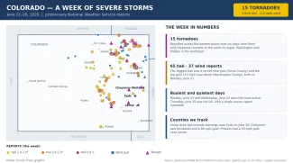
It was one of the most active severe weather weeks of the year across eastern Colorado. From June 21 through 26, the National Weather Service logged 15 tornadoes, 65 hail reports and 37 reports of damaging wind across the state's eastern half — including hail up to 4 inches in diameter and a wind gust clocked at 113 mph. Now the pattern flips: a hot, dry and windy stretch is setting in, shifting the main hazard from storms to wildfire as Colorado heads into the new week and the Fourth of July holiday.
A relentless week of storms
The week's storms favored the eastern plains, blossoming over the higher terrain most afternoons and racing east into the evening. The Storm Prediction Center's preliminary reports stretched from Bent and Cheyenne counties in the southeast to Logan, Washington, Phillips and Yuma counties in the northeast, with a scattering of large hail along the Front Range and foothills as well.
©
Preliminary hail, wind and tornado reports across Colorado, June 21–26, 2026.
(Kiowa County Press)
The hardest-hit days
Monday, June 22 was the peak. That day produced the week's largest hail — a 4-inch stone, bigger than a softball, near Joes in Yuma County — and its strongest wind, a 113 mph gust near Akron in Washington County, along with several tornadoes. Wednesday, June 24 brought the most tornadoes of the week, six, again concentrated across the northeast. The activity briefly collapsed Thursday, June 25, when just a single severe report — a 60 mph gust in northern Weld County — was logged statewide, before storms returned Friday.
Close to home
For the counties the Kiowa County Press follows most closely, the week's most pointed moment came Friday evening, June 26, when the Weather Service issued two tornado warnings that included Kiowa County as a supercell tracked near Eads and dropped 1.5-inch hail. Cheyenne County saw tornadoes near Aroya and Firstview and a 68 mph gust during the week, and Prowers County recorded a 58 mph gust near Lamar. No injuries or major damage were reported in the three counties, where the heaviest weather generally stayed just to the north. All storm reports are preliminary and subject to National Weather Service review.
The week ahead: hot, dry and windy
The stormy pattern is over for now. A ridge of high pressure building to the east and a trough to the west will lock in dry, southwesterly flow over Colorado through much of the coming week, the National Weather Service says. Expect above-normal temperatures statewide — highs in the 90s to around 100 on the eastern plains and the lower western valleys, cooler in the high country — with gusty afternoon winds that look strongest Sunday and Monday. Humidity will fall into the single digits to low teens, especially across western Colorado and the mountains, keeping critical fire weather conditions in the forecast day after day.
Rain will be hard to come by. Forecasters expect mostly dry weather into midweek, with only isolated, mostly high-based thunderstorms possible; where storms do fire over parched ground, dry lightning could spark new fires. A modest uptick in afternoon storm chances may return to the far eastern plains near the Kansas border later in the week as a little more moisture works back in, but confidence is low and any rain looks light. The early signal for the Fourth of July weekend is hot and dry — worth keeping in mind for anyone planning fireworks.
Bottom line
After a week defined by hail, wind and tornado warnings, the next one looks defined by heat and fire risk. Residents who spent the past week watching the sky for storms should now watch for red flag warnings and use extra care with anything that could spark a wildfire. The Press's separate fire-danger coverage maps the areas under a Red Flag Warning to start the week.


