Chance of rain returns - Kiowa County weather forecast for July 1, 2019

Monday kicks off a slightly cooler week across Kiowa County, with a chance for thunderstorms returning to southeast Colorado.
After approaching 100 for several days, high temperatures are expected to drop back to the low 90s today. Winds will be relatively light, with gusts up to 15 miles per hour. Look for north winds in the Haswell and Arlington areas, while Eads to Towner can expect wind out of the east and south.

Late day and early evening thunderstorms are possible, with the greatest potential coming to the western half of Kiowa County during the late afternoon before increasing county-wide in the evening. Most areas can expect less than one-tenth inch of rain, however greater amounts are possible where storms develop.
Overnight, low 60s return.
Tuesday, the cool-down continues with highs in the upper 80s predicted. The chance of thunderstorms also returns.
Currently, KiowaCountyPress.net Live Weather from downtown Eads shows [weather:currwinddir] wind at [weather:currwindspeed] mph. Sunday evening, winds were gusting to 29 mph. The current temperature is [weather:currtemp], with [weather:currrain] inches of rain so far today. Yesterday, 0.00 inches of rain was recorded in Eads, with an unofficial high of 100. The strongest wind gust since midnight was [weather:todaymaxwindspeed] mph, while the high temperature for the day so far was [weather:todayhightemp] at [weather:todayhightemptime].
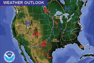
Elsewhere in Colorado, the risk for flooding has returned to mountain areas as higher temperatures have increased the mountain snow melt rate. Many rivers and streams are running at or near bank-full. Minor flooding is also expected along the Arkansas River in Otero and Bent counties as water is released from Pueblo Reservoir.
Kiowa County Weather Outlook for July 1, 2019 | |||||
Community | High | Low | Chance of Precip | Wind Gust | Direction |
Arlington | 92 | 62 | 60 | 15 | N |
Haswell | 90 | 62 | 50 | 10 | NNE |
Eads | 91 | 63 | 50 | 10 | ESE |
Brandon | 92 | 63 | 40 | 15 | SSE |
Sheridan Lake | 91 | 62 | 40 | 15 | SSE |
Towner | 92 | 62 | 40 | 15 | SSE |
Weather information updated throughout the day is available at http://weather.KiowaCountyPress.net.