Southwest Colorado is out of drought for the first time since January. Now an atmospheric river is aimed at ground that cannot take more

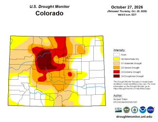
A week after a flood that set records on the Piedra and the San Juan, the U.S. Drought Monitor map released Thursday, October 29, shows Dolores, San Juan, Mineral and Rio Grande counties with no drought at all for the first time since January, and La Plata County drought-free for the first time since the end of 2024. Archuleta County had already cleared on the October 20 map. The same week, the National Weather Service in Grand Junction issued a hydrologic outlook for a second Pacific storm, an atmospheric river due Sunday and Monday, and warned that the ground it will fall on is still saturated.
"River flooding seems unlikely," the office wrote in Thursday morning's forecast discussion, "but localized impacts due to rainfall on saturated soils are expected."
The weekend ahead
The outlook, issued Wednesday afternoon for La Plata, Archuleta, Montezuma, Dolores and San Miguel counties and San Juan County, Utah, describes a low pressure system digging south from the Pacific Northwest on Friday and pulling a plume of Pacific moisture into the Desert Southwest. Showers and thunderstorms start Friday and Saturday with lighter totals, though the office said "a few thunderstorms could produce impactful downpours on saturated soils left over from last weekend's historic rainfall."
The deeper moisture arrives Saturday night. Forecasters expect 1 to 2 inches of new rain across southwest Colorado and southeast Utah on Sunday and Monday, mostly below 10,000 feet, with the heaviest amounts depending on small shifts in the plume's track. Rivers are forecast to stay below action stage because the rain will be spread over nearly two days. The concern is what the hillsides do with it: rock, mud and debris flows onto roads, and flash flooding on burn scars, in washes, slot canyons and arroyos.

© iStock - LuckyBusiness
Then it turns cold. A front crosses the region Sunday night, dropping snow levels to about 8,000 feet by Monday morning and near 7,000 feet by evening. Wolf Creek Pass is forecast to get 9 to 13 inches of snow Sunday and as much again Sunday night, with gusts to 45 mph, and the Grand Junction office expects travel slowdowns on the passes Monday. Highs Monday and Tuesday will run about 10 degrees below normal.
The town forecasts tell the same story in smaller numbers. Durango goes from a high near 65 on Friday to 50 on Sunday and Monday, with rain likely every period from Friday night through Sunday night. Pagosa Springs drops to 48 on Sunday with a 90 percent chance of rain Saturday night, and a chance of snow showers by Monday night. Silverton is forecast to see rain and snow showers through the weekend and 1 to 3 inches of snow Sunday night. Farmington, downstream of all of it, has a 100 percent chance of rain Sunday.
What the ground is holding
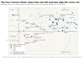
The reason the forecasters are careful is the week before. Rain from October 21 to 24 measured more than 4 inches at Wolf Creek Pass and in the Conejos and Rio Grande headwaters, and the Colorado Department of Transportation puts the totals near Pagosa Springs as high as 7 inches. The Piedra River ran at twice its previous record and the San Juan at Four Corners at nearly four times its record. The rivers have fallen fast since. The Animas at Durango, which peaked at 11,200 cubic feet per second on October 23, averaged 2,480 on Wednesday, and the San Juan at Pagosa Springs is down from 9,230 to about 1,370. Both are still falling.
©
The snow survey stations above the valleys already hold water. Wolf Creek Summit reported 12 inches of snow on the ground Wednesday with 4 inches of water in it, and Red Mountain Pass the same, according to the Natural Resources Conservation Service. Wolf Creek Summit has recorded 15.1 inches of precipitation since the water year began October 1.
A drought map wiped clean
©
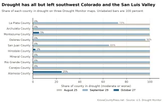
On the Drought Monitor map of August 25, every county in southwest Colorado and the San Luis Valley was entirely in drought. Hinsdale County was 89 percent in extreme drought and more than a quarter in exceptional drought, the worst category. Alamosa County was three-quarters exceptional. Mineral, Rio Grande and Conejos counties were more than half in extreme drought. Montezuma and San Juan counties were more than half extreme.
September's storms and the Polo rain at the end of the month started the retreat. By September 29, La Plata County was down to 6 percent severe drought and San Juan County to 3 percent, but the San Luis Valley counties were still mostly in severe drought, and Conejos was 86 percent extreme.

The Trudy flood finished it. On the October 27 map, drawn from rain through Tuesday morning, La Plata County is 90 percent free of drought or dryness, Archuleta and San Juan counties are entirely free, Mineral is 95 percent free and Dolores 89 percent. Rio Grande County is half free and the rest abnormally dry. Conejos is a quarter free. Montezuma County, which caught the least of the rain, still has 5 percent of its area in moderate drought, and Alamosa County, in the valley's rain shadow, has 25 percent. Not one of the ten counties has any severe, extreme or exceptional drought left.
Statewide, the share of Colorado in drought fell from 61 percent on October 20 to 50 percent on October 27, and the share with no drought or dryness doubled, from 16 percent to 35. Exceptional drought is down to 4 percent of the state, nearly all of it in the central and northern mountains the storms missed. Kiowa County and the rest of the southeast plains have been clear since early October.
©
The drought map measures rain, soil and streams, not what the year took. Vallecito Reservoir above Durango was 23 percent full on September 1 and is 88 percent full now, and Lemon Reservoir went from 32 percent to 84. Navajo Reservoir, which caught the San Juan's flood, has gained 330,000 acre-feet since September 1 and is 67 percent full. McPhee Reservoir on the Dolores is at 53 percent. Lake Powell, which takes all of it, has risen 14 feet since its September 15 record low. None of that undoes a winter with the lowest snowpack on record. The water managers' year starts over with the snow that the weekend storm is expected to leave on the passes.
The roads
The flood's cost is coming into focus on the highways, as the Press reported Thursday. On Wednesday the Colorado Department of Transportation asked the Federal Highway Administration for 65 million dollars in emergency relief funds for flood damage to federal-aid highways across southwest Colorado, and for 6.5 million of that, 10 percent, to be released immediately through the agency's quick-release process so work can start before winter. The Transportation Commission has already put up 5 million dollars in state emergency funds.

© Pixabay - Larisa Koshkina
Three highways took serious structural damage. U.S. 160 over Wolf Creek Pass reopened at 3:30 p.m. Tuesday after crews dealt with a failed culvert, a damaged retaining wall and pavement undercut by the Rio Grande, and the highway is one lane with alternating traffic west of Pagosa Springs. U.S. 550 over Red Mountain Pass between Ironton and Silverton is one lane while a washed-out embankment is stabilized. Colorado 151 at Chimney Rock is washed out in two places near mileposts 27 and 30, and the department plans a temporary access road for residents and emergency crews before it rebuilds the highway. The U.S. 160 bridge at Four Corners reopened Tuesday evening after inspections. Five other highways that closed during the storm, U.S. 285, Colorado 112, Colorado 17, Colorado 145 and U.S. 550 at the Bondad bridge, have all reopened.
"Unfortunately though, some of the damage will take time to permanently repair," said Julie Constan, the department's southwest transportation director. "We are in it for the long haul."
The 65 million dollars is a preliminary figure. High water has kept inspectors off some bridges, and the department expects a firmer estimate in eight to ten weeks, with more requests possible. The department said flooding stood 4 feet deep on some federal-aid roads at the peak.
Downstream in New Mexico
New Mexico moved faster on the federal side. Governor Michelle Lujan Grisham requested a federal emergency declaration Saturday for San Juan, Rio Arriba, Cibola and Sandoval counties and five tribal nations, and the president approved it Monday. The declaration brings the Army Corps of Engineers in on debris removal and damage assessments, the Geological Survey on flood monitoring, the Environmental Protection Agency on drinking water testing, and FEMA on shelter and water distribution. It did not include the reimbursement the state asked for, and the governor said she will seek a major disaster declaration once damage is assessed. She signed orders Monday adding 8.25 million dollars in state money to the response, and put emergency response costs at 4.5 million dollars by Saturday with 13.7 million more projected.
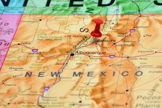
The San Juan River at Farmington, which set a record stage on October 23, was down to about 2,900 cubic feet per second by Wednesday. Sunday's rain is forecast to reach Farmington too, with a 100 percent chance of showers and thunderstorms.
What to watch
The Grand Junction office called its outlook preliminary and said the totals hinge on where the moisture plume sets up. The Albuquerque and Pueblo offices cover the New Mexico side and the San Luis Valley. Anyone in the areas that flooded last week, on a burn scar, or traveling the passes Sunday night and Monday should check the forecast again Saturday. Colorado road conditions are at cotrip.org and New Mexico's at nmroads.com.